

Waterfall hikes around Maine

Step Falls. Photo: Catherine Schmidt
By Carey Kish
JUST AS WE are drawn to the alpine heights of Maine’s windswept mountaintops or the seemingly endless expanses of sandy beach at the ocean’s edge, so, too, are we captivated by the thundering roar of waterfalls, the rainbows amid the glitter of the misty spray, the raw power of water rushing through rock crevices in the forest.
Waterfalls possess a secretive quality, nestled as they often are in deep ravines and dark valleys. We seek out these natural jewels via meandering paths, and upon arrival we are imbued with an awe-inspiring feeling of having discovered someplace truly special that, for at least a short time, is all ours to hold dear with delight and wonderment.
There are more than 360 named waterfalls of many different types in Maine, from block, cascade and fan falls to horsetail, plunge and punchbowl falls, and ranging across the state from Aroostook to Acadia, Cobscook to Cupsuptic and many places between.
Here is a selection of eight interesting and trail-accessible waterfalls. Pack your day pack with a picnic lunch and camera, invite some friends and family, and strike off for a fun waterfall hike in the Maine woods.
Be mindful in your foot travels, however. Waterfalls are beautiful, yes, but they are also inherently dangerous. Rough terrain and precipitous drop-offs, loose soil and wet, slippery rocks and roots are all potential hazards. Swimming may be possible if a safe place can be found to get into and out of the water and there is little or no current.
Gulf Hagas
National Park Service

Billings Fall, Gulf Hagas. Photo: Carey Kish
Popularly known as the “Grand Canyon of Maine,” Gulf Hagas is a natural gem in the heart of the 100-Mile Wilderness, a vast 750,000-acre region of woods, mountains, rivers and lakes in Maine’s North Woods. The National Park Service protects Gulf Hagas and its nearly 2,000 acres nestled between the White Cap and Barren-Chairback mountain ranges.
At Gulf Hagas, the West Branch of the Pleasant River drops 400 feet over four miles through a deep slate canyon, its vertical walls forcing the river into narrow channels that form a series of waterfalls, rapids, chutes and pools, all particularly spectacular in late spring during peak runoff.
From the trailhead on Katahdin Iron Works Road, a spur trail connects to the Appalachian Trail, which leads to the West Branch of the Pleasant River. The river, up to knee-deep under normal conditions, must be forded. Once across, the AT leads through The Hermitage, a towering stand of old growth white pines.
Not far ahead is Screw Auger Falls on Gulf Hagas Brook; this falls alone is worth the 1.5-mile hike, but determined hikers can continue through Gulf Hagas via the Rim Trail and Pleasant River Tote Road. This strenuous 8-mile loop visits Hammond Street Pitch, The Jaws, Buttermilk Falls, Billings Falls and Stair Falls, offering a cornucopia of scenic vistas en route.
VISIT GULF HAGAS
www.mainetrailfinder.com, www.northmainewoods.org
Town: Bowdoin College Grant East
Trails: Trailhead spur, Appalachian, Rim, Pleasant River Tote Rd.
Distance & Time (round trip): 4–8mi., 3-5hr.
Rating: Moderate-Strenuous
Hadlock Falls
Acadia National Park

Waterfall Bridge at Hadlock Falls. Photo: Carey Kish
Hadlock Brook descends from the heights of Sargent and Cedar Swamp mountains in the thick of Acadia National Park. At Hadlock Falls, the brook makes a 40-foot drop over Hadlock Falls before cascading under Waterfall Bridge, one of seventeen old stone bridges of the park’s famed carriage road system.
View the falls from the broken-stone road over the bridge, or better yet, walk down and around to enjoy the falls from below, framed by the magnificent arch of the bridge. Acadia’s 45 miles of carriage roads, stone bridges, signposts, and coping stones were the brainchild of philanthropist John D. Rockefeller, who financed their design and construction from 1913 to 1940.
Hadlock Falls can be reached by footpath from Route 3/198. Hadlock Brook Trail leads one-mile to the falls at Waterfall Bridge. Return to the trailhead by way of the carriage roads, passing over Hemlock Bridge and then making two left turns at succeeding junctions. Turn onto Parkman Mountain Trail and then Hadlock Brook Trail to complete the loop.
VISIT HADLOCK FALLS
www.nps.gov/acad
Town: Mount Desert
Trails: Hadlock Brook, carriage roads, Parkman Mountain
Distance & Time (round trip): 2.1mi., 1.5hr.
Rating: Moderate
Jewell Falls
Portland Trails

Photo: Carey Kish
Situated in a beautiful ravine cloaked with tall white pines and stately hemlocks, Jewell Falls is the only natural waterfall within the city limits of Portland. Nason’s Brook flows over the falls in a single 30foot cascade and into the salt marsh below, eventually merging with the Fore River on its way to the sea.
The land around Jewell Falls was donated to Portland Trails by Tom Jewell, one of the founders of the celebrated urban land trust, and is now part of the 85-acre Fore River Sanctuary. Since 1991, Portland Trails has helped create an outstanding system of parks, open spaces, and green corridors, crisscrossed by some 70 miles of multi-use trails. Use the Forest City Trail to reach Jewell Falls from the trailhead at the end of Hillcrest Street, an easy half-mile stroll. At the pretty footbridge at the head of the falls, saunter down the rock steps to a granite bench, a perfect spot to view the falls.
Visit Jewell Falls
www.trails.org
Town: Portland
Trails: Forest City
Distance & Time (round trip): 1mi., 1hr.
Rating: Easy
Katahdin Stream Falls
Baxter State Park

Photo: Carey Kish
Tumbling more than 108 feet over four tiered drops, Katahdin Stream Falls is the last and perhaps the most beautiful waterfall on the Appalachian Trail, the fabled long distance pathway that stretches from Springer Mountain, Georgia to Maine’s mighty Katahdin in the midst of Baxter State Park’s 210,000 acres of wildlands.
From Katahdin Stream Campground, meander toward the falls in the footsteps of those hardy hikers who make the grueling four-to-six month trek northbound nearly 2,200 miles to this point, just five miles shy of the terminus high above on windswept Baxter Peak at 5,268 feet.
For one mile, the Hunt Trail, the route of the Appalachian Trail on Katahdin, follows sparkling Katahdin Stream before crossing it on a log bridge. Katahdin Stream Falls is just a stone’s throw beyond at 1.2 miles from the trailhead. Several short but steep side trails on the left lead to fine viewpoints of the falls as well as the narrow canyon just below.
Visit Katahdin Stream Falls
www.baxterstateparkauthority.com
Town: T3 R10 WELS
Trails: Hunt (AT)
Distance & Time (round trip): 2.4mi., 2hr.
Rating: Moderate
Little Wilson Falls
National Park Service

Photo: Carey Kish
Cascading an impressive 57-feet into a deep and dark slate canyon, the upper part of Little Wilson Falls in Elliottsville Plantation is one of the highest waterfalls, not only in Maine, but along the entire Appalachian Trail. Several viewpoints at the top, which make nice picnic spots, and partway down the north side of the falls, can be accessed from the trail.
The trailhead is reached via a lovely drive from State Route 15 in Monson on Elliottsville Road, which features views of craggy Borestone Mountain along the way. Just before the bridge over Big Wilson Falls on the left is a woods road that dead-ends a mile in at the site of a former primitive campground.
Here, at the base of the lower part of Little Wilson Falls, is the start of the Little Wilson Access Trail, which climbs 400 feet in 1.3 miles to join the Appalachian Trail a short distance from the upper falls.
Lower Little Wilson Falls is a 20-foot slide drop into a huge pool, a fine swimming hole on a hot summer day. Above, the trail leads past a series of small falls and rapids, then two 8-foot falls and plunge pools.
Visit Little Wilson Falls
www.mainewoodstourism.org
Town: Elliottsville
Trails: Little Wilson Access, Appalachian
Distance & Time (round trip): 3mi., 2.5hr.
Rating: Moderate
Kees Falls
White Mountain National Forest
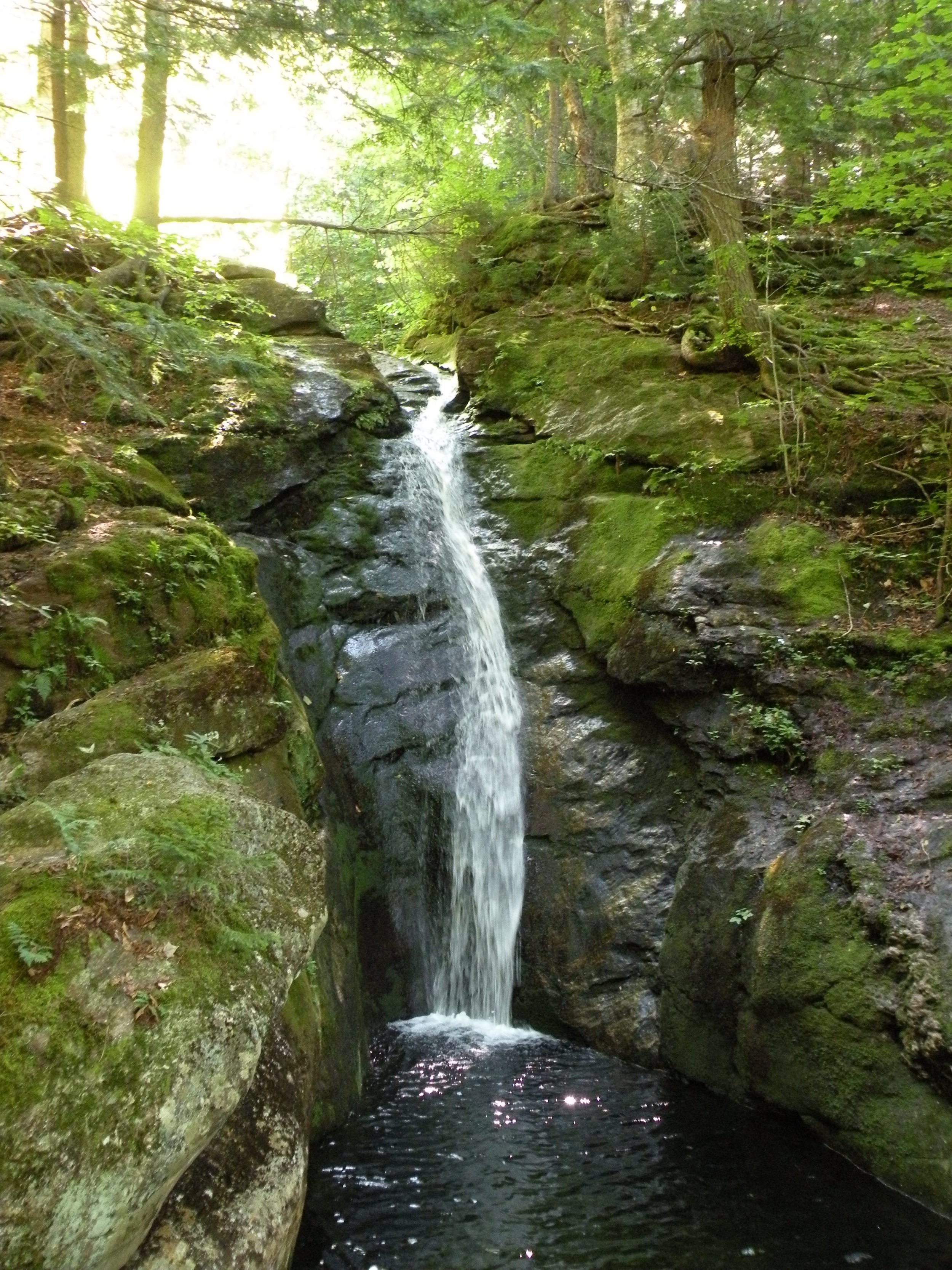
Photo: Carey Kish
Caribou Mountain in the Caribou-Speckled Mountain Wilderness has all the elements of a perfect day hike: two clear and cold streams, one waterfall, extensive open ledges and incredible summit views, all reached by a loop hike of moderate mileage.
Along the Caribou Trail, just two miles from Route 113 on the north side of Evans Notch, is lovely Kees Falls, where Morrison Brook pours 25 feet down through a narrow mossy green grotto to empty into the huge pool below. The trail crosses the brook at the top of the falls, then a side path descends steeply on its north side to a good view of the falls at poolside.
Enjoy a relaxing break or a picnic amid the refreshing spray of the falls before deciding on the next step. Options include returning to the notch via the route in or perhaps continuing on to the summit of Caribou for rewarding views of the Carter-Moriah and Presidential mountain ranges, then looping back via Mud Brook Trail.
Visit Kees Falls
www.mainetrailfinder.com
Town: Bachelders Grant
Trails: Caribou
Distance & Time (round trip): 4mi., 3hr.
Rating: Moderate
Moxie Falls
Bureau of Parks & Land

Moxie Falls during spring runoff. Photo: Carey Kish
Thundering 90 feet straight down into a deep gorge, Moxie Falls is arguably one of Maine’s highest, an impressive sight that reminds visitors of Mother Nature’s raw power. Moxie Falls is reached by a popular one-mile hike from Lake Moxie Road that is mostly flat and pretty easy at first up to an old woods road.
Beyond a welcome sign for Moxie Falls State Scenic Area, the trail gets a little steeper but is still reasonable, while the noise of the falls ahead becomes noticeably louder. The trail leads first to a vantage point at the top of the falls, with a bird’s eye view down the gorge. Continuing on, the trail meanders down slope for a better look. Several wooden platforms provide viewpoints for the obligatory panorama and selfie photos.
Moxie Stream originates at the dam on Moxie Pond several miles above the falls and continues to flow down into the Kennebec River Gorge below. If the thrill of rushing water has you itching for more, consider signing up for a whitewater rafting trip on the Kennebec or Dead rivers. There are plenty of outfitters in The Forks willing and able to guide you down the wild, foamy rivers.
Visit Moxie Falls
www.mainetrailfinder.com
Town: Moxie Gore
Trails: Moxie Falls
Distance & Time (round trip): 2mi., 1.5hr.
Rating: Easy
Step Falls
Mahoosuc Land Trust

Photo: Catherine Schmidt
Hemmed in by rugged cliffs, steep slopes and alpine summits towering more than 4,000 feet, the deep defile of Grafton Notch in the Mahoosuc Range of western Maine is one of the state’s wildest regions. Just south of the notch, a series of spectacular waterfalls splash down the mountainsides in close proximity to Route 26; pretty Step Falls is among them.
Step Falls was acquired by The Nature Conservancy in 1962, its first Maine preserve. In 2012, ownership of Step Falls and the surrounding 24 acres was transferred to Mahoosuc Land Trust, which works to conserve lands along the Maine-New Hampshire border.
Wight Brook plunges more than 250 feet from the slopes of Lightning Ledge and Dresser Mountain above, tumbling down in a series of lovely cascades and pools and earning Step Falls a place among the highest falls in Maine. An easy path leads quickly to the base of the falls, where the trail continues to climb through fragrant forest to the upper reaches of the braided stream and views west over Grafton Notch.
Visit Step Falls
www.mahoosuc.org
Town: Newry
Trails: Step Falls
Distance & Time (round trip): 0.5-1.0mi., 1hr.
Rating: Easy-Moderate

Further resources
A helpful reference for home use is New England Waterfalls: A Guide to More Than 400 Cascades and Waterfalls by Greg Parsons and Kate Watson, which describes falls according to type, height, trail length and difficulty, water source and the best season to visit, with ratings for beauty. The venerable DeLorme Maine Atlas & Gazetteer is a handy companion in the car for navigating Maine’s highways and byways. Lastly, the Appalachian Mountain Club’s ever-trustworthy Maine Mountain Guide has been the go-to resource for the state’s mountain trails for over half a century.
Photo: Carey Kish
