

Maine’s state parks: 5 gems to visit this year

Looking out across Moosehead Lake from the tower on Mt. Kineo. Photo by Carey Kish.
By Carey Kish
From Alpine Peaks of granite and leafy green hills, sparkling blue lakes and ponds and pristine rivers and streams to long stretches of sandy beach, spruce-studded peninsulas, remote islands and rugged headlands, Maine is home to a remarkable array of natural landscapes. Incredibly, some 4 million acres of the state’s total land area have been preserved in some form of conservation, including more than 1 million acres that are owned and managed by the state.
Of this bounty, Maine’s state park system encompasses 67,000 acres across 36 park units, ranging from Aroostook County to the Camden Hills and Quoddy Head to the Mahoosuc Range. Visitors can hike, camp and fish, watch birds, ride a bike, go for a swim, relax with a picnic, and enjoy boating, canoeing and kayaking in spring, summer and fall, while in wintertime there’s cross-country skiing, snowshoeing, snowmobiling and ice fishing.
Here’s an insider’s look at five of Maine’s amazing state parks.

A group of Portland friends enjoy the hike up Quaggy Jo Mountain on a recent trip to Aroostook County. Photo by Sam Piro.
Aroostook State Park, Presque Isle
Expansive farmlands and deep green forests, lovely lakes and rivers, abundant wildlife and friendly, hospitable local folks characterize Aroostook County, Maine’s largest county. One of the must-see natural gems of “The County,” Aroostook State Park is located just off U.S. Route 1, a few miles south of Presque Isle.
Aroostook State Park holds the distinction of being Maine’s first state park, created in 1938 with 100 acres of land donated by the citizens of Presque Isle. Subsequent donations have increased the size of the park to today’s 900 acres, which encompass the rugged twin peaks of Quaggy Jo Mountain and shorefront on pretty Echo Lake.
Three miles of hiking trails combine for an inspiring circuit over Quaggy Jo, affording fine vistas over the bucolic Aroostook countryside. There’s also good birding, plus picnicking, swimming, fishing and boating on Echo Lake. Thirty campsites tucked into the woods above the lake offer a quiet and restful place to spend the night.
Close to the park’s entrance, find Double Eagle II Memorial Park, which marks the August 11, 1978 launch site of the first successful trans-Atlantic balloon flight. On the drive along U.S. Route 1 to Aroostook State Park, enjoy the roadside exhibits of the world’s largest three-dimensional scale model of the solar system.
Shackford Head State Park, Eastport
The dramatic oceanfront headlands of Shackford Head are a wild and scenic natural jewel located on the edge of Eastport, the easternmost city in Maine and the U.S. Shackford Head State Park captures 90 acres of this craggy peninsula, which is bounded by Cobscook Bay to the west and Broad Cove to the east.
The area is named for one of Eastport’s earliest settlers, Captain John Shackford, who brought his family here around 1783 and lived most of his 87 years on the headland. In the 1970s, Shackford Head was the proposed site of an oil refinery but was successfully opposed because of the significant navigational hazards posed by the strong tidal waters as well as the land’s ecological value. The state of Maine acquired the land and established the park in 1989.
Rich in history as well as natural beauty, the area’s trailhead signs tell the tales of Civil War ships of the Union Navy that were brought to Cony Beach between 1901 and 1920, salvaged for their copper, brass, iron and other valuables, and then burned.
Seven hiking trails totaling three miles wend through Shackford Head State Park and offer a grand tour of its natural highlights, including Schooner Overlook, Ship Point and Shackford Head Overlook. Fragrant, mossy green forests, rocky bluffs and cobble beaches mark the perimeter paths, which offer plenty of island and ocean vistas, lobster boats, sailing vessels and aquaculture pens.
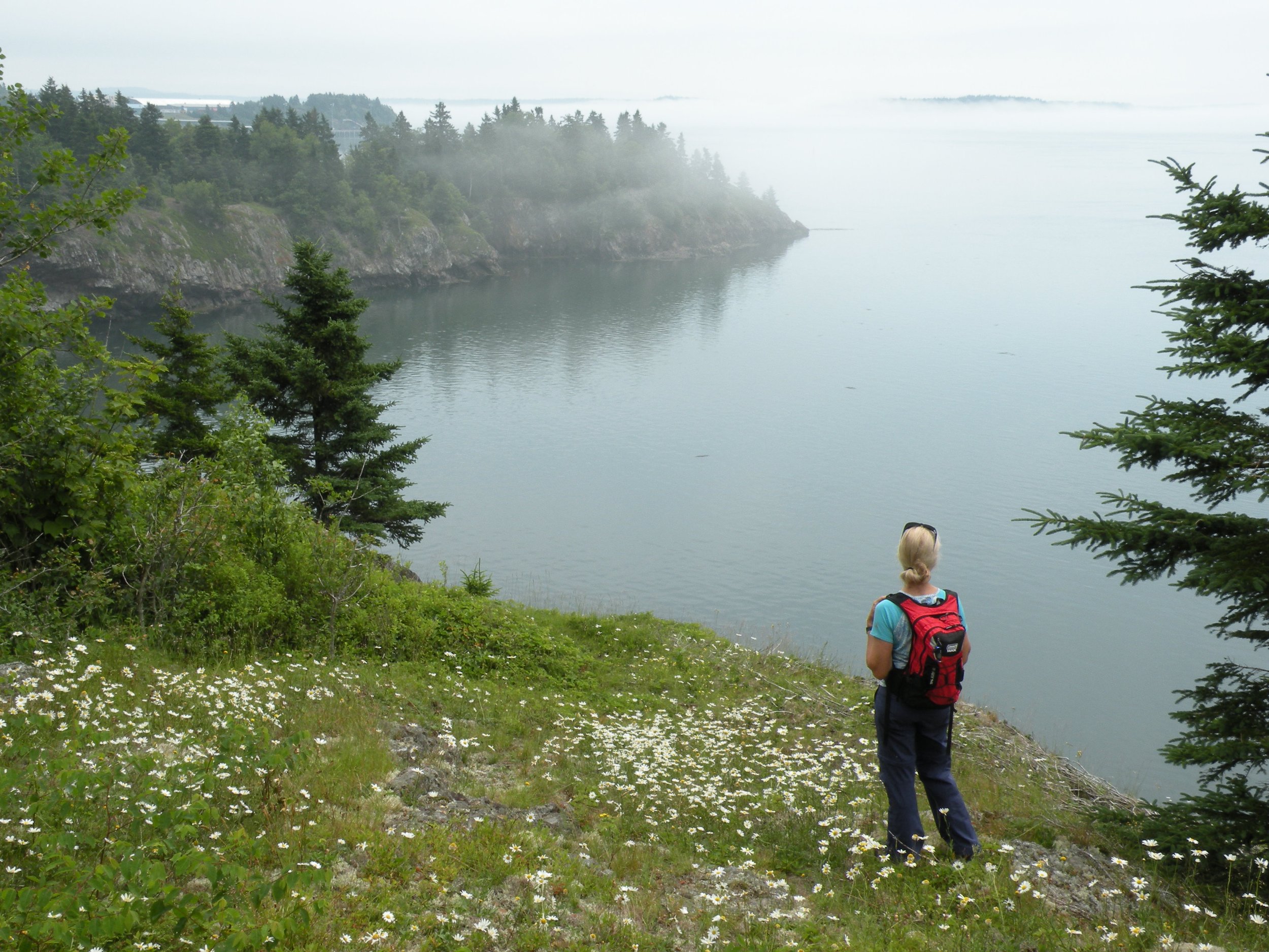
A hiker looks out toward Ship Point at Shackford Head State Park as the sea fog floats in. Photo by Carey Kish.
Holbrook Island Sanctuary, Brooksville
Bordered by Penobscot Bay, the Bagaduce River and Smith Cove, Holbrook Island Sanctuary occupies 1,230 acres – including the namesake Holbrook Island – on the north end of the Cape Rosier peninsula in Brooksville. Holbrook Island was settled after the Revolutionary War by Captain Jesse Holbrook of Truro, Massachusetts and once supplied white pine logs to be used as masts for sailing ships built in nearby Castine.
Miles of old roads, foot paths and animal trails turned into formal walking paths guide visitors through the sanctuary’s diverse ecosystems and wildlife habitats. Explore the estuary and salt marshes of Goose Pond and the rocky shores, mudflats and sandy beaches of Penobscot Bay and Smith Cove. Then continue to the volcanic rocks of Backwoods Mountain and the beaver and muskrat lodges and eagle and osprey nesting sites around of Fresh Pond.
Part of the state park system, the sanctuary was the gift of Anita Harris, a longtime resident of Holbrook Island who acquired the land in the 1960s and donated her holdings to the state in 1971 “to preserve for the future a piece of the unspoiled Maine that I used to know.” The local author Reta Farnham Hunter tells the story of Holbrook Island, Anita Harris and how the sanctuary became a reality in Anita’s Island: A History of Holbrook Island.
Peaks-Kenny State Park, Dover-Foxcroft
The stunning view from the sandy strand of beach at Peaks- Kenny State Park draws your eyes northward over sprawling Sebec Lake to the precipitous slopes of Borestone Mountain and beyond to the summits of the Barren-Chairback Range and the route of the Appalachian Trail, a glorious scene from roughly the geographic center of Maine.
The 839-acre park was established in 1969, five years after the land was donated to the state by Francis J. Peaks, a prominent Dover-Foxcroft citizen and attorney. The beautiful white sand beach at South Cove was a favorite picnic spot of Annie Peaks Kenny, Peaks’ sister, and his parents, Joseph and Eliza Peaks, hence the hyphenated name of the park.
Swimming and frolicking on the grassy lakeside promenade are the most popular summertime activities at Peaks-Kenny, which protects a mile of Sebec Lake shoreline. Birch Mountain Ledge Trail and Brown’s Point Trail are among the five miles of trails that provide plenty of opportunity for woodsy exercise. The 56-site campground just west of the beach is nicely wooded and peaceful.
Take in some art along with the views with a dozen unique “picnic table” sculptures scattered throughout Peaks-Kenny, created by local artist Wade Kavanaugh through Maine’s Percent for Art Act. These fun tables with benches are tucked in next to boulders and around trees, making for an interesting meeting of art and nature.

Looking north from the Sebec Lake beach at Peaks-Kenny State Park towards Borestone Mountain. Photo by Carey Kish.
Mt. Kineo State Park, Kineo Township
Mt. Kineo rises dramatically from a peninsula jutting out from the eastern shore of Moosehead Lake, just north of Rockwood. The sheer 700-foot southeastern face of the 1,789-foot mountain, comprised of ancient rhyolite rock, is visible from many points around Maine’s largest lake and is the region’s most iconic landmark. Mt. Kineo is reached by a 10-minute ride aboard the Kineo Shuttle from the Rockwood Public Landing.
In 1990, the state of Maine purchased 800 acres of land, from the cliff face northward to the tip of the peninsula, to form the state park. The remainder of the land at Kineo is privately owned and features a golf course with a club house and a number of summer cottages. Built in the 1880s to entertain guests of the Mt. Kineo House (once the largest inland hotel in America with accommodations for more than 500; all three iterations burned over time), the public course is the second oldest in New England.
Four trails combine for about five miles of outstanding hiking. Scramble to the summit ridge and the old fire tower (circa 1917) that has been turned into an observation tower for a sweeping vista – perhaps the finest in Maine – that extends east far beyond Moosehead Lake to the majestic apex of Katahdin, as well as west across a jumble of remote mountain peaks to the Canadian border.
Find more information on Maine’s state parks, public lands and historic sites at www.parksandlands.com.
